The Ireland Way
  • DISCOVER
  • TRAIL
  • SHOP
  • NEWS
  • FAQ

Frequently Asked Questions

IMPORTANT INFORMATION!
The trail is almost complete. Do bare in mind that it is very new and will take several years to be up to the standard of other popular trails around the world. Some stages are well developed and others are not fully way-marked or may even be overgrown in parts. A number of people have walked the trail in its entirety and it is not without challenges!

Join the Ireland Way Facebook Group Page to follow updates from hikers on the trail or ask questions.

YOU WILL GET LOST
A GPS is still essential so that you can regularly check that you are still on track. Check maps with your current location if you have not seen a way-marker for a while. Some stages are very well way-marked and others are not. Expect to wander off track once or twice!

YOU WILL FIND A PLACE TO STAY
Some parts of the trail have plenty of accommodation, others are lacking. There is also not much budget accommodation. Most hikers are finding wild-camping the best way to do the trail. If you prefer to stay in accommodation such as Bed & Breakfasts, it will require planning along the way and the occasional taxi if the accommodation is off-trail. Hikers are finding local people to be very helpful in giving advice for a camping spot or the nearest accommodation. There will always be a place to stay; just be willing to take a taxi off-trail sometimes.

YOU WILL GET WET
Roughly 50% of the trail is on road. The 50% that is off-road goes through fields and often boggy areas. Hikers have reporting being "ankle deep". Use hiking poles. Wear waterproof socks. Waterproof everything! Summer is the driest time of year and the ground is much more firm, but bogs are wet all year round.

THE TRAIL IS NOT FULLY FINISHED
The Leitrim Way is under re-development so official maps are not yet available. The latest update is that all new way-marking is now in place, however it is not yet ready or open to hikers. The Lung/Lough Gara Way is still undergoing re-routing. Way-markers are still lacking in a few other parts of the trail.

CYCLING
The cycle trail is mostly on road and overlaps with the walking trail in many parts, roughly 50%. The Beara-Breifne Way cycle trail is not fully way-marked. The Ulster Way does not have an official cycle route, however most of the trail is on road. ​You cannot cycle the walking route on the Beara-Breifne Way due to hundreds of stiles, farmland with cattle and unsuitable terrain. To date, no one has cycled the entire route on the cycle trail. Join the Facebook Group Page to see how they get on.
Ulster Way Note:
​Stages 14 and 19 are called 'link sections' and it is advised to use transport for these two sections as they follow busy roads. For more information go to www.walkNI.co.uk/ulsterway
Where can I find maps for the trail?
​
A guidebook with maps and accommodation for the trail is available in our  Shop. Alternatively, maps for complete sections are available to download for free from www.IrishTrails.ie and www.WalkNI.com/ulsterway. There are also Beara-Breifne Way maps on noticeboards in most towns which may be useful to photograph as you pass them.
Glen of Aherlow Beara-Breifne Way Ireland Way hiking trail
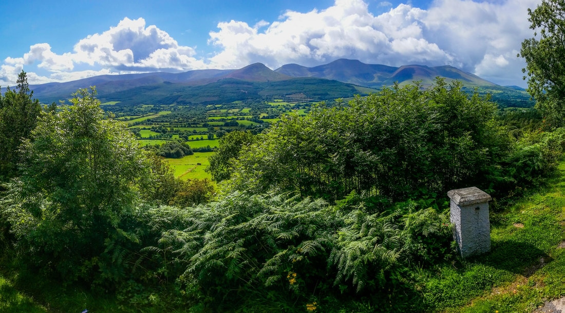
Glen of Aherlow and Galtee Mountains

Guidebook Updates to 2nd Edition

Picture
P108, map 29, blocked stile
Picture
P110, map 30, unmarked right turn
Stage 2, Slí Gaeltacht Mhuscraí, Ballingeary - accommodation with Mary Murphy, Inchigeelagh B&B, 0863627209.

Stage 3, North West Cork Way, Newmarket - accommodation in the village in Scanlon's Bar. To book phone 029 60003.

Stage 9, Lung/Lough Gara Way is still undergoing re-routing and way-markers are in place for both the old and new route which makes it confusing at times.

Stage 11, Leitrim Way has been undergoing re-development. Most, if not all, way-markers are now in place, however it is not yet ready or open to hikers.


Accommodation
Is there plenty of accommodation along the way?
​
Accommodation consists of mostly Bed & Breakfasts with only a few hostels, hotels and campsites. Most of the trail has enough accommodation within a day's walking distance, though not all. Budget for taking at least four taxi's to accommodation and to get dropped off again the next morning. Some accommodation-owners in rural areas may be willing to collect you. AirBnB can be useful for extra accommodation options and is noted in the guidebook in areas with a shortage of other accommodation. Accommodation is sparse in Northern Ireland from Stages 13 to 18, see paragraph below regarding distances. Try to book accommodation in the smaller towns in advance. Some accommodations are closed during the winter months. Be flexible and ask a local if you are stuck. They are very friendly and will advise of the nearest accommodation.
How much does it cost to walk the trail?
​
There are currently 6 hostels on the trail and they charge around €18-€25 per bed per night. The rest of your accommodation are Bed & Breakfasts and a few hotels which can cost around €60 - €90 for two people sharing with breakfast included. More hostels will likely open up over the coming years which should make the trail more budget-friendly in the future.
What about camping and campsites?
On the Ireland Way there are only a handful of campsites. However, wild-camping is allowed. Most land is privately owned and hundreds of farmers have kindly given permission for walkers to go through their land, so out of respect, if you see a house near where you want to camp it is polite to ask permission first. You can also ask in the local pub if they can suggest a suitable place to camp. You may be offered someone's garden! Usually in the mountains or rural areas where there is no house nearby you can camp freely. Just be sure to take your litter with you.
Statue Celtic Sea God Beara Breifne Way Ireland Way hiking trail
Statue of Celtic Sea God
Time & Distances
How long does it take to walk/cycle?
​
To walk the entire 900-km/500-mile trail takes around 40 days. Cycling the trail takes roughly 2 week. To-date the fastest thru-hike is 36 days by Tom & Marc Glintschnig.
What are the distances to walk each day?
Walkers will need to be able to walk from 5km up to 29km in a single day.

Four sections may require a taxi to pick you up half-way if you are unable to walk these distances. The guidebook gives suggestions for these:
Stage 13: Belcoo to Belleek: 46 km
Stage 14/15: Pettigo to Mellon Country Hotel: 45 km
Stage 16: Gortin to Moneyneany: 37 km
Stage 18: Dungiven to Castlerock: 60km (accommodation mid-way 3 km off-trail)
When is the best time of year to walk the trail?
The summer months, June, July and August will be the warmest and driest time of year to walk the trail. These three months are the main tourist season so some accomodation could be full at weekends. Book accommodation a few days in advance if you can or be prepared to take a taxi. The trail is the most pleasant at this time of year with lush green landscapes.

March and April are the next best time to walk the trail. It is spring time and trees are starting to grow new leaves and new lambs may be seen prancing in the fields. March weather varies, April is warmer.

September weather varies a lot. it could be a nice warm sunny September or a wet and windy one! There may be stormy days followed by sunny days.

October is getting much colder and wetter and the sunligh-hours getting shorter.

November, December and February are very wet and can be very windy and go below freezing.  Only walk these months if you enjoy that kind of weather and come well prepared with suitable warm and waterproof clothing. Deep invisible puddles in long grass, plenty of mud, large puddles, sliding into bog up to your knees, thick fog in the mountains and a risk of hyperthermia if you get stuck in the mountains alone. If you are lucky, ice will harden the ground and make it more walkable. The days are also much shorter with daylight from around 8.30am to 5.30pm.
Safety
Is it safe to travel alone in Ireland?
​
You can read about the safety of travelling alone in Ireland on Tripadvisor.
Is there any danger from animals on the trail?
The primary danger to look out for are bulls. They are extremely dangerous.
Each time you enter a field scan it thoroughly before proceeding. Bulls generally have a ring in their nose. In springtime cows with calves can also be very dangerous. ​When passing through cattle fields always keep to the perimeter to allow quick escape if necessary.
Picture

How much of the trail is on road?
​
Approximately 50% of the trail is currently on road. Although most of the roads are very quiet country roads, it is advised to take care and wear a high-visibility jacket. Flashing lights may be used for additional visibility.
Are there any unsafe parts I should know about?
​
As they are not yet finished, the main sections to be careful on (or use public transport for) are stages 6, 9 and 11. Some trails cross busy motorways. Use caution walking on roads or crossing roads and wear a high-visibility jacket.
Dogs & Horses
Can I bring my dog?
Dogs are not permitted on most of the Stages. This is because the trail goes through farms with livestock. Permission has been granted for walkers to pass through these farms on condition that dogs are not allowed. You can check each Stage of the trail separately on www.irishtrails.ie and www.walkni.co.uk to see if dogs are permitted.
Can I do the trail by horse?
Currently it is not advised to do the trail by horse. You would need to use the cycle route (all on road) as the walking trail has many stiles in and out of private land. Many of these roads may not be suitable for horses. We hope to have more information regarding this in the future.
Provinces & Counties
What counties does the Ireland Way pass through?
​
On the Ireland Way you will pass through all four provinces; Ulster, Munster, Leinster and Connaught and a total of 14 counties:
  • Cork
  • Kerry
  • Limerick
  • Tipperary
  • Offaly
  • Galway
  • Roscommon
  • Sligo
  • Leitrim
  • Cavan
  • Fermanagh
  • Tyrone
  • Derry
  • Antrim

Social

Picture
Facebook
Picture
Instagram
Picture
Twitter
Picture
Tripadvisor
Picture
Pinterest

About

About Us
Contact Us
Legal Terms
Picture
Picture
Picture
Picture
Ireland Way © 2018. Ireland Way is a Registered Trademark.
  • DISCOVER
  • TRAIL
  • SHOP
  • NEWS
  • FAQ